
Juan de Herrera Drill Hole Summary Result Tables:
| Property | Juan de Herrera, concessions covering ~ 12,746 hectares |
| Location | Dominican Republic: Tireo Gold Trend of central Hispaniola. Concessions adjacent to GoldQuest Mining’s Tireo Project which hosts the gold-copper Romero deposit |
| Summary | Gold exploration focused on the discovery of intermediate sulphidation epithermal and VMS style deposits |
| Ownership | 100% ownership of all concessions, subject to a 3% NSR on various concessions. 1.5% of NSR can be purchased by Company for $2.0M |
Latest News from Juan de Herrera
In April of 2025 the Company announced results from the latest follow up hand trench rock channel sampling, infill soil sampling and prospecting within the newly identified CN Zone. As previously reported, results from recent rock sampling, within the CN Zone soil anomaly, returned individual sample values including 73.8 g/t gold, 34.9 g/t gold and 11.7 g/t gold, and 8.7 g/t gold* from selective high-grade rock grab samples. Follow up prospecting, rock and hand trench channel sampling in the zone expanded the surface trace of the CN Zone to an estimated 300m, and to date, 11 hand trenches have been created and chip-channel sampled over the surface trend of the gold-enriched structure and returned results as follows:
- Trench 15: 6.4 g/t gold, 6.5 g/t silver, 2.8 g/t Au over 3.8m
- Trench 16: nil Au, poorly exposed structure zone.
- Trench 11: 7.2 g/t gold, 16.6 g/t silver over 1.0m, within 3.7 g/t Au over 3.75m
- Trench 10: nil Au. Poorly exposed structure zone
- Trench 9: 7.2 g/t gold, 5.0 g/t silver over 2.0m, within 3.9 g/t Au, 4.2 g/t Ag over 5.0m
- Trench 8: nil Au. Poorly exposed structure zone
- Trench 7: 4.3 g/t gold over 0.6m (off-trend and down slope from main structure)
- Trench 5: 83.6 g/t Au, 29.0 g/t Ag over 1.0m and 0.13 g/t Au over 7.0m
- Trench 4: 0.2 g/t gold, 2.1 g/t silver over 1.0m
- Trench 3: 32.2 g/t gold, 286 g/t silver over 5.1 metres
- Trench 2: 1.5 g/t gold, 12.6 g/t silver over 3.0 metres
- Trench 1: 1.0 g/t gold, 8.8 g/t silver over 4.0 metres
- Exploration has extended the surface trace of the gold-rich structure past a distance of 300 metres, having identified an offset extension of the zone only 30 metres west of its previously identified southern extent. The structure remains open to the south, has a northwest-southeast trend and dips about 50 degrees to the northeast, with an apparent width ranging from 0.5 to 6.0 metres.
- The gold enriched structure is located on the east limit (up slope side) of the gold-in-soil anomaly which covers an estimated area measuring about 725 metres (north-south) by up to 300 metres (east-west). Soil samples are affected by significant down slope dispersion, directed from east to west.
In August 2024 Precipitate announced results from various programs of field, desktop and laboratory work along with the review and analysis of existing data. The Company collected over 17,000 individual soil samples on grid parameters as detailed as 25 metre by 50 metre spacings within multiple known areas of interest throughout the project. Approximately 8,000 samples showing elevated base metal and pathfinder elements (from XRF scanning)warranted full laboratory analysis. Analytical results from this project-wide sampling program identified eight priority zones of elevated gold and/or base metals (copper, lead and zinc) in soil anomalies and has also refined the extents of several notable pre-existing soil anomalies at the Southeast, Peak and Melchor zones. These newly delineated zones are Ginger Ridge North, CN, CN 2, CN 3, CdN, CdN 2, CdN 3, and GM. Early field observations of various surface rocks (float and outcrop) have led the Company to prioritize three zones for immediate follow up exploration, those being CN, CdN, and GM zones.
As follow up, crews commenced a more detailed program of sampling and mapping within these new zones and the latest results have outlined two zones of near-term priority interest, the CN zone and the GM Zone. To date the CN zone has emerged as a top priority based on its elevated gold grades, geological affinities, and overall size.
CN Zone
Selective high grade rock grab samples (float) with very strong iron oxides (after pyrite) and silica-quartz yielded values of 73.8 g/t gold, 34.9 g/t gold, 11.7 g/t gold, and 8.7 g/t gold*, with more representative outcrop grab samples yielding values ranging from 2.2 to 6.3 g/t gold. Located within the north-central region of the Project area, rock and soil sampling has demarked an area measuring about 700 metres (north-south) by up to 300 metres (east-west), where the multi-element soil anomaly is open to the north and south.
GM Zone
Seven of the 21 rock samples (float/subcrop and one outcrop) report anomalous gold values, including 4.3 g/t gold and 1.4 g/t gold, with associated pathfinder elements of arsenic, copper, selenium, lead and zinc. Located at the northern end of the Project area, rock and soil sampling has outlined an area measuring approximately 450 metres (northwest-southeast) by up to 250 metres (southwest-northeast) where the multi-element soil anomaly is open to the north and the east.
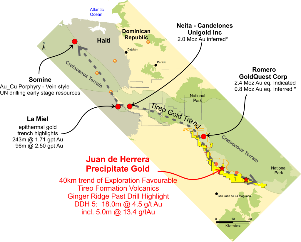
Juan de Herrera Project Location
Precipitate’s Juan de Herrera project is well located within the prospective Tireo Gold Trend in western Dominican Republic. The Juan de Herrera (“JDH”) project is variably road accessible and covers an estimated 40 kilometres of prospective strike length of target Tireo Formation lithologies (see property maps). The Tireo Formation is an Upper Cretaceous aged package of volcanic and sedimentary rocks that bisects central Hispaniola, trending northwesterly through the Dominican-Haitian border. These rocks were largely unexplored until recent discoveries by GoldQuest Mining Corp (Romero), Unigold (Neita-Candelones) and Newmont (La Miel). Approximately 5.0 million gold equivalent ounces have been discovered and advanced in in the belt in the last decade, while vast areas of similarly prospective and proximal terrain remains largely underexplored.
Juan de Herrera NI 43-101 Technical Report (March 2016)
Project Technical Milestones and Highlights
- JDH Project acquired in 2012 via option agreement, then earned 100% interest in 2016. Project footprint subsequently expanded via staking.
- Completion of maiden property wide regional-scale prospecting and geochemical sampling yields numerous gold/copper/zinc targets (2015-16).
- Detailed exploration at six areas: Ginger Ridge (+GR East), Southeast, South Jengibre, Peak, Melchor and JT; with a number of other regional targets yet to be followed up on.
- Helicopter airborne high-sensitivity magnetic and radiometric geophysical survey complete.
- Focused exploration at Ginger Ridge Main Zone (2014-17): including detailed soil and rock sampling, geological mapping, multiple phases of IP & magnetic geophysical surveys, and 3,270 metres of diamond drill testing. Identification of a combined VMS-intermediate sulphidation mineral system and discovery hole GR14-05 with highlight result of 18.0m @ 4.54 g/t gold.
- Tireo Gold Camp data sharing and collaboration agreement with GoldQuest Mining Corp.
- Extensive regional scale IP (induced polarization) geophysical survey program completed over the current five priority exploration zones. Numerous combined chargeability/resistivity anomalies identified.
- Complete first property scale geological mapping program covering all major focus areas.
- Identification of Ginger Ridge East Zone VMS mineralization target via soil and trench sampling; follow up drill program of 8 holes for 811 metres total (2017).
- 2024-25 renew exploration with submittal of soil samples in storage to laboratory
- Identification of > 8 new geochemical anomalies, which have now seen various phases of prospecting, geological mapping and hand trenching.
- Ongoing surface sampling, geological mapping and induced polarization geophysics, as combined means for efficient drill hole targeting.
Current Focus and Goals
- The Company has initiated a follow up program at the CN, GM and Centro zones, where exploration work will include additional prospecting, rock sampling, infill and extension soil sampling, coarse geological mapping and where warranted, selective hand trench channel sampling.
- Additional diamond drill testing and geological interpretation of the Ginger Ridge East Zone VMS mineralization target, with a goal of identifying similar VMS style mineralization as recently discovered at GoldQuest’s nearby “Cachimbo Zone”.
- Southeast, South Jengibre, Centro, Peak and Melchor Zones: Additional exploration target refinement for drill testing of the numerous high level multi-layered geophysical, geochemical and geological anomalies. The Southeast, Centro and South Jengibre zones are the near term focus. Especially the recently identified copper enriched Southeast Zone Trench 7 area (3.0m of 2.78% copper within 8.0m of 1.28% copper).
- 2025 Planned exploration includes additional soil samples in storage to be submitted to the laboratory, infill and expanded induced polarization geophysics, hand trenching and drill site planning.
Ginger Ridge Main and East Zones Exploration Summary
Precipitate’s primary exploration focus is to identify intermediate sulphidation epithermal and VMS styles of mineralization. Since announcing its initial Dominican Republic property acquisitions in 2012, the Company has completed multiple phases of regional and local scale exploration work. Most JDH Project high level exploration programs have focused on the Ginger Ridge Main Zone and the nearby Ginger Ridge East Zone, while the Ginger Ridge South zone has seen limited exploration including surface sampling and trenching and single drill hole GR17-15.
Detailed exploration at Ginger Ridge Main Zone includes geological mapping, rock-soil sampling, hand trenching, multiple phases of induced polarization and ground magnetic geophysical surveying and 15 diamond drill holes totalling 3,270m (3 phases).
Early drilling (2014) at the Ginger Ridge Main Zone discovered a new zone of gold-enriched massive sulphide mineralization; ‘discovery hole’ GR14-05 cut 98.1 metres of strongly disseminated, semi to massive sulphides (dominantly pyrite), containing an 18.0 metre wide interval of 4.54 g/t gold (including 5.0 metres at 13.37 g/t gold. Holes reported from Phase 2 drilling (holes 7 to 11) were not as robust as the mineralization identified in the discovery hole. Subsequently completed holes GR17-12 to 15 reported results for the Main and South parts of the Ginger Ridge area. Highlight results include the discovery of mineralization in a previously untested anomaly to the south of the Main zone yielding a 1.1 m interval of 2.59 g/t gold in hole GR17-15 and a Main Zone drill intercept of 14.73m of 1.16 g/t gold, including 2.67m of 2.23 g/t gold from hole GR17-13.
Ginger Ridge Main Zone Surface Sampling and IP Geophysics
Soil and rock sampling has established a northwest-southeast trending surface gold anomaly (plus pathfinder elements) about 2.0 kilometres. The enriched multi-element core anomaly is characterized by a correlation of gold and silver with several pathfinder elements which variably include arsenic, antimony, barium, lead, copper, thallium and zinc. Surface sampling at Ginger Ridge covers an estimated area measuring 2,200m by 750m, blanketing most of the eastern slope of Ginger Ridge. IP geophysical surveys cover an area measuring approximately 1.6 km by 1.0 km, blanketing much of the zone’s multi-element surface geochemical anomaly that marks anomalous mineralization in Tireo volcanic rocks.
Ginger Ridge East Zone Surface Sampling
In early 2017, the Company announced soil sampling results from the newly identified gold-in-soil geochemical anomaly Ginger Ridge East zone, located approximately 1.0km east of the Main Ginger Ridge anomaly. Subsequent comprehensive and concentrated soil sampling program (density of 25m by 25m) demarcated a robust soil anomaly measuring >1,000 metres long by an estimated average width of 100 metres (up to 200m wide locally). The northwest-southeast trending soil anomaly reports elevated gold, lead and zinc values throughout the surface anomaly along with intermittent copper values. . Geological mapping of this drill priority area shows the Ginger East area to be underlain by very similar gold-copper-zinc enriched andesite-dacite volcanic rocks as noted at the GoldQuest Mining Cachimbo VMS discovery nearby to the northwest.
Additional Zones at Juan de Herrera
Regional sampling and mapping in early 2016 identified 5 geochemical anomalies, Southeast, Jengibre South, Melchor, Peak, and JT. All five areas are coincident with regional airborne magnetic anomalies and are hosted within favourable Tireo volcanic lithologies. The 2017 induced polarization (“IP”) geophysical programs covered the Ginger Ridge, Southeast, South Jengibre, Peak, Melchor and JT zones. Where a total of ~80 line kilometres were surveyed (including the 2014 Ginger Ridge IP geophysical work). In addition, the Company collected ~ 73 line kilometres ground magnetic readings as an add on to the regional airborne magnetic geophysical data set.
Southeast Zone
- 650 m by 125m multi-element soil anomaly with gold up to 144 parts per billion (“ppb”), plus various pathfinder elements (open in all directions, except to the southeast);
- Northwest trending soil anomaly coincident with important geophysical features, including moderate-high IP chargeability and resistivity and magnetic low signatures important for potential gold mineralization in the region;
- Discovery of a new early stage high grade copper showing with strong disseminations of chalcopyrite (rock grab samples reporting up to 13.5% copper, 0.5 g/t gold, and 52.1 g/t silver*); Continuous rock chip results from Trench 7: 3.0m of 2.78% copper, within 8.0m of 1.28% copper within a broader 18.0m of 0.70% copper; and
- Sampling of other areas between Southeast and South Jengibre has reported copper values up to 1.1% and gold values up to 1.1 g/t
South Jengibre Zone
- 350m by 150m multi-element soil anomaly with gold up to 229 ppb, open to the southeast;
- Gold-in-soil anomaly correlates with pathfinder elements, zinc and lead, with lesser silver and antimony;
- Soil anomaly is coincident with moderate IP chargeability and high IP resistivity and moderate magnetic low signatures;
- Located two kilometres south of GoldQuest Mining’s Jengibre zone, where past work reported highlight rock channel sampling results of 59.5 metres grading 1.58 g/t gold (see GoldQuest news release of October 7, 2009) and rock samples to 17.7 g/t gold and 1.4% copper; and
- Rock grab sampling has reported gold values up to 5.2 g/t and 1.25 g/t across a 4.0 metre outcrop
Melchor Zone
- Target area measuring 2.2 km by 0.6 km including three parallel and fairly well defined multi-element soil anomalies with gold up to 181 ppb;
- Highlight rock grab sampling with gold values up to 7.7 g/t Au;
- The three southeast trending soil anomalies are further defined by various geophysical features of mixed moderate-high and low IP chargeability-resistivity and magnetic low signatures, important for potential gold mineralization in the region; and
- Geological mapping indicates much of the area to be underlain by regionally favourable rhyolite and dacite rocks.
Peak Zone
- Target area measuring 2.0 km by 0.7 km, includes four loosely outlined multi-element soil anomalies with gold up to 286 ppb;
- Highlight rock grab sampling with gold values up to 1.57 g/t Au and copper values to 0.6%;
- Geophysical responses including mixed moderate-high and low IP chargeability-resistivity and magnetic signatures; are coincident with the soil anomalies;
- Located 4.5 km southeast of GoldQuest Mining’s Jengibre zone, where past work reported highlight rock channel sampling results of 59.5 metres grading 1.58 g/t gold (see GoldQuest news release of October 7, 2009) and rock samples to 17.7 g/t gold and 1.4% copper; and
- Sampling of other areas between Peak and Melchor zones has reported gold-in-soil values up to 490 ppb and a rock grab sample with 0.47 g/t gold and greater than 1% zinc.
* NOTE: Surface rock grab samples are selective by nature and are unlikely to represent average grades of the zone.


Maps


Photos


